Category Archives: Cities & Towns

Dividing Lines

Kansas City remains one of the most segregated cities in America, with Troost Avenue serving as a de facto dividing line running north and south through the heart of the city. Journey through the history of social, physical, and economic segregation in Johnson County and Kansas City with the Dividing Lines tour on the VoiceMap app via your smartphone.

Horizontal rectangular black and white copy photograph of school exterior on hill, viewed from slightly below. Three story rectangular brick building with large windows. Several bare trees. Sidewalk at right winds uphill to entrance. Handwritten in bottom margin:"SM - East."

Shawnee Mission East High School (Photo courtesy of the Johnson County Museum Collection on JoCoHistory.org)

Starting at Shawnee Mission East High School, the app will direct you along a route that tells the story of segregation in our community that ends at the Ivanhoe Community Center. The tour is designed so that you can safely drive through the city at your own pace while hearing stories about each area you pass. The 90 minute tour includes insightful context and fascinating interviews from area residents and notable Kansas Citians like activist Mamie Hughes, executive director of the Ivanhoe Community Center Margaret May, author and Kansas City Star columnist Bill Tammeus, and attorney Sidney Willens.

Horizontal rectangular black and white film negative of aerial view of Prairie Village. Area is primarily residential. View looks west. Roe Avenue runs left-right above the center of the image. Mission Road runs left-right along the bottom of the image. Tomahawk Road runs diagonally from the upper left to the bottom edge near the center. 71st Street runs from Mission Road to Roe Avenue to the left of the center of the image. 67th Street runs from Mission Road to the upper right corner of the image. Commercial development on Tomahawk Road near its intersection with Mission Road. Portion of airplane strut visible in top left corner.

Aerial view of Prairie Village looking west. Roe Avenue runs left-right above the center of the image. Mission Road runs left-right along the bottom of the image. Tomahawk Road runs diagonally from the upper left to the bottom edge near the center. 71st Street runs from Mission Road to Roe Avenue to the left of the center of the image. 67th Street runs from Mission Road to the upper right corner of the image. (Photo courtesy of the Johnson County Museum Collection on JoCoHistory.org)

The Dividing Lines tour guides listeners through the history of segregation in the Kansas City metro areas of Johnson County, Kansas, and Kansas City, Missouri. It primarily discusses segregation through the areas’ real estate and some of its most recognized landmarks. The tour courses through neighborhoods that are considered the crown jewels of the metropolitan area as well as neighborhoods that fell victim to redlining, blockbusting, and white flight. The app tour explains how and why these neighborhoods look the way they do today. It is a complex story that few people know yet continues to unfold and affects our everyday lives.

Color postcard of landscaped area along a street and stone bridge in Mission Hills. The horizontal image has a white border. The view is of a residential area. A portion of a large house is at the extreme left. The street curves near the right of the image. The house is partially obscured by trees. The stone bridge is at the right of the road and is arched over a small waterway. Flowers are in bloom at the right. The postcard was not postally used. The back has a space for the message at the left and the address and stamp at the right. Museum label: "2005.34.2" Black text in upper right corner: "PEMBROKE LANE, MISSION HILLS, KANSAS CITY, MO" Black text in lower right corner: "97996" Vertical text on the back, along left edge: "PUBLISHED BY R. B. HARNESS GREETING CARD CO., KANSAS CITY, MO." Vertical text on the back, at the center: "C. T. AMERICAN ART COLORED" above loco for "C T" "Chicago"

Postcard of Mission Hills (Photo courtesy of the Johnson County Museum collection on JoCoHistory.org)

“Dividing Lines” was created as a part of the Johnson County Library’s “Race Project KC.” The Library’s Civic Engagement Committee’s “The Story of Segregation in Kansas City” bus tour and Tanner Colby’s book “Some of My Best Friends are Black: The Strange Story of Integration in America” inspired much of the ongoing work of Race Project KC. This tour was made possible by support from Johnson County Library and the Kansas Humanities Council. It was produced by Brainroot Light & Sound, and written by Nathaniel Bozarth (“Wide Ruled”) and Christopher Cook. The tour features music from Hermon Mehari and KC Jazz.

The content of this tour may contain controversial material; such statements are not an expression of library policy.

Get more information and download the app now.

-Johnson County Library staff


1 Comment

Filed under Cities & Towns, Research

“An Ideal Home in an Ideal Location with Ideal Surroundings:” Richard Hocker’s Suburban Developments in Merriam, Kansas

By the turn of the 20th century, industrialization in Kansas City resulted in overcrowding, pollution, and disease. Looking to escape these less-than-desirable conditions, Kansas City’s upper-middle classes sought homes in new suburban developments in northeast Johnson County. The advent of the electric trolley led to “streetcar suburbs,” which made transit into downtown accessible and convenient.

One such suburban neighborhood was planned by Richard Weaver (R.W.) Hocker, who was a banker and real estate developer in Kansas City, Missouri. Envisioning early suburban development in Johnson County, the “R. W. Hocker Subdivision” was platted in 1910 for eight 5-acre lots. One of two houses originally built, the “Walker House,” was added to both the State and National Registers of Historic Places in March 2017.

3-story house with limestone porch

This image from Google Maps shows the Walker House as it appears today at 5532 Knox Street.

The Walker House is a single-family dwelling built between 1906 and 1911 (the Kansas State Historical Society estimated 1910). The home, located at 5532 Knox Street, was built as a “spec house,” short for “speculative,” essentially serving as a model for the neighborhood’s intended development. The home’s first occupant was Mrs. Azubah Denham, the wife of Rev. B.Q. Denham. Rev. Denham was a popular pastor in Johnson and Wyandotte Counties in the 1890s. Between 1904 and 1910, however, he had become infamous for adultery and indecency scandals in Buffalo and New York City. In 1911, Azubah Denham purchased the Walker House in her name only for $5,500 ($137,500 in 2015). In 1920, many working class families lived on less than $1,500 per year, so the home’s price illustrates the intended middle-class nature of Hocker Subdivision.

Architecturally, the Walker House is indicative of the Kansas City Shirtwaist Style, named for ladies fashion at the beginning of the 20th century. Shirtwaist dresses included a seam at the waist where the material often changed. The Shirtwaist influence is evident in the Walker House: a single-floor local limestone exterior, an upper floor and a half of cedar clapboard, and flared gable eaves on the eastern face and one-story porch. Inside, original woodwork, including oak and pine hardwood floors, contribute to the historic character. The Walker House originally sat on a large 5-acre lot, but today occupies just .31-acres.

Hocker Grove area of Johnson County atlas map

This excerpt from the 1922 Standard Atlas of Johnson County, Kansas, shows both of Hocker’s residential developments. The Walker House occupied Lot K, located in the upper right. (Johnson County Museum, http://www.jocohistory.org/digital/collection/atlas/id/138/rec/4)

Hocker also platted “Hocker’s Grove” in 1915. This neighborhood contained 1-acre lots for modest—but still middle-class—Craftsman bungalow homes. Just seventeen were originally constructed. Both neighborhoods were within a half-mile walk from the “Hocker Line,” an inter-urban, electric trolley that was speculated to extend from Kansas City to Lawrence and even Topeka (it reached as far as Mill Creek, to the east of Zarah, or about two miles west of I-435 today). By 1907, the trolley ran the the seven-and-a-half miles between Kansas City and Merriam. Residents could reach Union Station in 35-minutes, the intersection of 12th and Main Streets in 45-minutes, and make connections to Kansas City’s urban trolley line along Southwest Blvd.

Trolley station at Hocker Grove, 1915

The Hocker Line Trolley Station near Merriam. This image appeared in the 1915 Hocker Grove promotional booklet. (Johnson County Museum, http://www.jocohistory.org/digital/collection/jcm/id/5594/rec/25)

Hocker promoted his neighborhoods with the slogan, “The Home For You.” A promotional booklet printed in 1915 testified that buyers would find “an ideal home in an ideal location with ideal surroundings.” The booklet indicated that the “modest, artistic homes in a restricted neighborhood” were equipped with natural gas, fronted on macadamized rock roads, and were located in “natural and picturesque beauty.” Buyers could take advantage of flexible deferred payment plans, as well. The “restricted neighborhood” wording communicated to white, middle-class buyers that the area was reserved as residential for a twenty-five year span, and that no African Americans could purchase or lease the homes there for 100 years. This developer’s tool of racial segregation, often referred to as a “deed restriction,” was used throughout Kansas City and Johnson County’s suburban neighborhood developments, as well as across the nation during the 20th century suburban boom.

Hocker Grove homes located on the southeast and northeast corners of the intersection of Knox Street and Hocker Drive, 1915

These Hocker Grove homes are located on the southeast and northeast corners of the intersection of Knox Street and Hocker Drive. Both streets were called “Avenues” in 1915. Image from the 1915 Hocker Grove promotional booklet. (Johnson County Museum, http://www.jocohistory.org/digital/collection/jcm/id/5595/rec/27)

Hocker Trolley line map

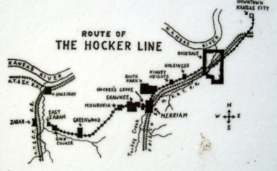
An undated map of the route of the Hocker Line electric trolley. The trolley line followed the Frisco and Missouri, Kansas, and Texas Railroad lines. (Johnson County Museum)

Both of Hocker’s neighborhood developments were located near Hocker Grove Park, a 40-acre amusement park that Hocker planned and built with O.M. Blankenship between 1907 and 1908. The park was located on Hocker Drive, north of Johnson Drive today. This amusement park featured roller-skating, dancing under a large pavilion with a Wurlitzer automatic band organ (the pavilion doubled as a basketball gym), and was the site of balloon ascensions, professional boxing matches, and picnics. Families rode the Hocker Line from Kansas City to enjoy picnics in the natural setting. There was also a 2,000-seat grandstand for watching baseball games, an extremely popular sport at the time. A “Trolley League” soon developed with six semi-professional baseball teams.

Picture of the Hocker Grove 'Trolley League' baseball team, 1908

The Hocker Grove “Trolley League” baseball team, c. 1908. (Johnson County Museum, 1990.025.018)

Crowds skating at the Hocker Grove skating rink, 1908-1915

A postcard image of the Hocker Grove Park skating rink, c. 1908-1915. (Johnson County Museum, http://www.jocohistory.org/digital/collection/jcm/id/11817/rec/30)

Hocker was not the only real estate entrepreneur working in the area. Increased real estate competition in and around Merriam at the time of Hocker’s developments may have limited the construction there. After all, despite the beauty and convenience of Hocker’s two neighborhoods, only 19 homes were built between them. William B. Strang’s competing interurban trolley line and his suburban developments, most notably Overland Park, were located nearby and were equally convenient, beautiful, and middle-class in nature. Hocker died in 1918, and his amusement park closed the following year. After more than a decade of financial difficulty, the Hocker Line trolley closed for good in 1934. By then the automobile had become accessible for Johnson County families.

In the century since the construction of the Walker House in the R. W. Hocker Subdivision and the smaller Craftsman homes in Hocker’s Grove, most of the empty lots have been built upon, the large lots have been subdivided, and many historic homes have been remodeled or razed. Yet it is still possible to discern the beauty of the location and, with Interstate 35 following the Hocker Line into Kansas City almost exactly, the convenience remains evident. Hocker’s suburban dreams for his neighborhoods nestled between Merriam and Shawnee have been thoroughly realized today, if not during his lifetime.

2 Comments

Filed under Cities & Towns, People, Research, Sports Teams

Origin of Kill Creek’s Name

kill_creek1

Kill Creek Park. Photo courtesy of JoCo Parks & Rec District

Have you ever driven down K-10, maybe on your way to Lawrence or De Soto, Kansas, and glanced at the Kill Creek Road exit or visited Kill Creek Park and wondered how they got their name? There is an actual creek called Kill Creek, and this is the namesake of the road and park, but how did it get the name Kill? Over the last year, we have received several inquiries about the origin of Kill Creek’s name, and we wanted to share our findings. With help from our friends at the Johnson County Parks and Recreation District, we have discovered the origin of the name, and it’s probably not what you think.

There are several creeks on the East Coast that include the word “Kill” in their name. The word “Kill” may allude to a violent act that took place in that geographical area. However, in most cases these creeks are named Kill or Kille after the Middle Dutch term for creek or body of water. This is true for Johnson County’s Kill Creek Road and Kill Creek Park between Olathe and De Soto. The name simply means body of water.

We hope this quells any confusion or lingering curiosity you may have had about Kill Creek.

-Beth Edson, Johnson County Library

9 Comments

Filed under Cities & Towns, Research

The Last Stand of Elizabeth Porter

In 1941, the great real estate developer, J. C. Nichols, began planning his newest community: Prairie Village.  While Nichols would later come to regard Prairie Village as one of his jewels, the development was far from easy.  Several obstacles stood in Nichols’ path; a snaking creek that had to be straightened, and a large farmer-used landfill that needed to be covered and graded were just two of the many problems that had to be dealt with.  But one of the largest obstacles that Nichols had to contend with came in the form of a 70-year old woman named Elizabeth Porter.

Elizabeth Porter, born in 1871, was the daughter of Thomas C. Porter, Sr.  Thomas Porter had come to Johnson County in the 1870s and had purchased 160 acres of land that sat between what is today 61st Street and 71st Street, bisected by Mission Road.  When Porter Sr., died, his acreage was divided up amongst his five children: Elizabeth, Harold, Edgar, James, and Thomas Jr.

When J.C. Nichols was planning the community of Prairie Village, he had envisioned a large shopping area to be situated at the center of the development, right where Elizabeth Porter was living.  Elizabeth had been given the family homestead as part of her inheritance; she had lived her entire life in the two-story farm house that now stood in the way of progress.

Elizabeth Porter (center) with her father, Thomas Porter (right) and her aunt, Carrie Porter (left) in front of the Porter family homestead ca. 1900

Having already purchased the land held by the other four Porter children, Nichols went to Elizabeth to buy the 16 acres that she owned.  At 70 years old, Elizabeth was in failing health and was not yet ready to part with the only home she had ever known. Nichols knew that this situation had to be handled as delicately as possible if he wanted to see his vision for Prairie Village realized.  Elizabeth told Nichols that she would sell her portion of the land to him on one condition: that she be allowed to live in the home as long as she wished.  Nichols agreed and, in 1942, Elizabeth sold the remaining Porter family land to the J. C. Nichols Company.

Aerial photograph of Prairie Village. The Prairie Village Shopping Center (center) sits on the 16 acres of Porter family farmland that belonged to Elizabeth Porter.

Elizabeth Porter continued to live in the family home until 1947, when, with her health rapidly declining, Elizabeth knew she could no longer live in the house.  In a supremely touching gesture, Elizabeth was presented with a new, modern home in Prairie Village built by the J.C. Nichols Company.  The new house was located on Prairie Lane west of Mission Road on the northern-most edge of their family’s old property.  Elizabeth lived in this home until her death in 1951.

House built in Prairie Village which was given to Elizabeth Porter by the J.C. Nichols Company

-Katie Keckeisen, Johnson County Museum

Leave a comment

Filed under Cities & Towns, Research

Historic Church Buildings in Lenexa

Salem Lutheran Church and Holy Trinity Catholic Church are just some of the Lenexa, Kan., institutions that date back to the late 1800s. This was a time when populations from different backgrounds traveled west for reasons that include railroad expansion and land opportunities. Groups of settlers brought with them a variety of religions and beliefs. Thus, Lenexa has an intriguing assortment of church buildings, many that have been reconstructed since their beginnings.

Salem Lutheran Church 

An influx of German settlers that practiced the Lutheran faith found themselves in need of their own church around the 1880s. Salem Lutheran Church was organized in the fall of 1885 with 10 charter members (SLC, 2015). In the early days, services were preached in German and Sunday School in English.

salem church 1800s

Photo courtesy of the Salem Lutheran Church

In 1922, a tragic fire destroyed the original Salem Lutheran building. A new building was constructed, adorned with beautiful stained glass windows, a new pipe organ and other additions. The new church building opened on May 24, 1924.

Salem_Lutheran_Church

Salem Lutheran Church, circa 1990. 9135 Haskins Street, Lenexa, Kan.

Holy Trinity Catholic Church

Holy_Trinity_Catholic_Church 1800s

Holy Trinity Catholic Church, 1882. 9138 Pflumm Road, Lenexa , Kan.

Twenty families in Lenexa requested permission to start a Catholic parish in 1880. The request was approved (one can assume by the Catholic Church) and in 1882, a small white framed church was built for the Holy Trinity Catholic Church.

By 1911, the parish had significantly grown in numbers and a new larger building constructed of stone was completed. Approximately 2.8 million pounds of rock was brought to the site by parish members and their wagons (HTCH, 2015).

Holy_Trinity_Catholic_church_circa_1988

Holy Trinity Catholic Church, circa 1988.

As Lenexa experienced a population boom in the 1990s, a new church was built in 1996 to accommodate Holy Trinity’s growing parish. As you can see, the architecture is modern and quite different from the other two buildings before it.

Holy_Trinity_Catholic_Church__Observance_of_their_120th_Year

Holy Trinity Catholic Church, circa 2000.

-Beth Edson, Johnson County Library

References

Holy Trinity Church. (2015). Our parish history. Retrieved from http://www.htlenexa.org/our-parish-history

Salem Lutheran Church. (2015). History. Retrieved from http://www.htlenexa.org/our-parish-history

Leave a comment

Filed under Cities & Towns, Research

Sunflower Army Ammunition Plant Portrait: Gayla Frazier

Working at the Sunflower Army Ammunition Plant in northwest Johnson County was truly a family affair.  Fathers and sons, husbands and wives, mothers and daughters all worked at the plant together.  Even those who were not related by blood talked about the family atmosphere at Sunflower throughout the years.  Gayla Frazier represents the third generation of her family who worked at Sunflower.  The Gardner native worked at Sunflower from 1965-1973, and from 1975-2002.  Frazier started out as a clerk typist and rose to become the only female plant manager in Sunflower history.  Frazier held that position for four years until she retired.

Gayla Frazier in 1972.

Gayla Frazier in 1972.

Frazier’s grandfather worked as a laborer and helped build Sunflower during World War II.  She said her grandfather told great stories about building the plant, and the thing he remembered most was the mud; “rain or shine they would be out working.”  As the war progressed, the rocket powder produced at Sunflower became a crucial element in the Allied war strategy.  Construction continued throughout the war, and Sunflower workers played an important role and helped the Allied forces win World War II.

Construction at Sunflower in January 1944.

Construction at Sunflower, January 1944.

Frazier’s father, Elden Lovelett, worked at the plant from 1951-1986 and in his later years served as Chief of the Sunflower Fire Department.  Frazier also had two uncles and a great aunt who worked at the plant.  Frazier recounted how her great aunt told her that she used to smuggle matches and cigarettes into Sunflower inside her sandwiches to avoid security measures.  Smoking was strictly prohibited because of the risk of explosion, and cigarettes and matches were considered contraband.

Sunflower Fire Department, 1967.

Sunflower Fire Department, 1967.

Frazier looks back fondly on her time at Sunflower.  Her fondest memory of the plant?  “The people I met.”  She still attends a monthly breakfast with former co-workers and keeps in touch with others by phone and email.  Sunflower produced millions of pounds of rocket powder for nearly five decades, but perhaps more importantly the plant fostered a family atmosphere, literally and figuratively.

The quotes included in this article are part of a formal oral history collected by the Johnson County Museum that is accessible in our archives.  The Museum conducts oral history interviews with local residents in an effort to capture firsthand accounts and stories from the past.  Gayla Frazier’s interview was one of more than a dozen conducted by Museum staff in 2013 to gain more information about the history of the Sunflower Army Ammunition Plant.  The material was used to inform an exhibit created for the Museum entitled “Citizen Soldiers on the Prairie.”  The exhibit is on display until August 23.

– Matt Gilligan, Johnson County Museum

Sunflower workers in 1954.

Sunflower workers, 1954.

Leave a comment

Filed under Cities & Towns, Government, People, Research

A Piece of History in Strang Park

When the sun is shining, it’s time to head outside. How about visiting local history sites in your neighborhood?

Overland Park and much of the rest of Johnson County grew and developed as a result of William B. Strang and the electric interurban railroad he built to provide convenient travel between Kansas City and the new suburbs. If you’d like to read more about how Strang got started, take a look at our previous post on Overland Park  and this article from the Johnson County Museum: “The Overland Turnpike: William Strang and His Interurban Railroad”. Strang chose to build his railroad on high ground to avoid the hazards of flooding, and much of the track ran parallel to the old Santa Fe Trail, from which the Oregon Trail splits off just west of Gardner.

There are remnants of the Strang Line tracks in Strang Park at 89th and Farley, just behind Johnson County Library’s Central Resource Library. In honor of the Santa Fe Trail, there are additional historical markers describing and mapping the western migration to Oregon, California and the Southwest.

While you’re in the neighborhood, we invite you to stop by the Central Resource Library and browse our books and resources about the Santa Fe Trail!

Leave a comment

Filed under Cities & Towns, People, Research

Johnson County’s “In Cold Blood” Legacy

Truman Capote’s “In Cold Blood” is sometimes called the first “non-fiction novel.”  The book documents the 1959 murders of four members of the Clutter family in Holcomb in southwest Kansas.  The two men ultimately captured and executed for the crimes play a major role in the book and in the 1967 film adaptation.  Although these brutal crimes took place over 350 miles away from the area, one man’s connection to Edgerton thrust Johnson County into the spotlight.

Richard Eugene “Dick” Hickock was born in Kansas City, Kansas in 1931.  His parents relocated their family to rural Edgerton in 1945 to get away from city life.  Edgerton’s residents learned early on that young Dick Hickock was a charming con man who was not to be trusted.  Although he was a popular athlete at Edgerton Rural High School, Hickock had a reputation for stealing money and goods from local residents and businesses.  After graduating from high school, Hickock worked as a mechanic in a local shop with his father.

Dick Hickock's Junior year photo, Edgerton Rural High School, 1948.

Dick Hickock’s Junior year photo, Edgerton Rural High School, 1948.

Hickock had run-ins with the law throughout the 1950s until he was sent to the state penitentiary in Lansing in 1958 for theft.   There he befriended a fellow petty thief named Perry Smith.  Both men were released from prison only months before they committed the murders that made them household names.  Hickock and Smith were arrested in Las Vegas on December 30, 1959, six weeks after the murders in Holcomb.  The men were tried, found guilty, and executed at Lansing in 1965.  Truman Capote’s book detailing the case was a huge hit, and plans for a film version of “In Cold Blood” developed quickly.

Dick Hickock in prison in 1960.  Photo by Richard Avedon.

Dick Hickock in prison in 1960. Photo by Richard Avedon.

Director Richard Brooks wanted “In Cold Blood” to be accurate, and he filmed at the  actual locations when possible.  When parts of the film  were shot in Johnson County in March 1967, Brooks was initially turned away by the Humphrey family, who owned the Hickock’s land near 207th Street and Spoon Creek Road near Edgerton.  They changed their minds after Brooks offered them money to shoot on the property.  The Hickock family home and Dick’s 1949 Chevy appear in the film.  Some residents were not happy with the Hollywood presence, and the Humphreys received hateful letters in the mail.  Ray Braun’s gas station in Edgerton was also used for filming.  Braun was paid $50 per day.  When the production moved southwest to Holcomb, Brooks filmed in the actual house where the Clutter murders occurred.

The film version of “In Cold Blood” debuted in December 1967 to rave reviews.  The film is regarded as a classic, and the story of the Dick Hickock, Perry Smith and the Clutter family murders continues to garner interest locally and nationally.

– Matt Gilligan, Johnson County Museum

"In Cold Blood" movie poster from 1967.

“In Cold Blood” movie poster from 1967.

6 Comments

Filed under Cities & Towns, People, Research

Mission Township in Johnson County’s Historical Atlases

Have you ever browsed through the historical atlases at JoCoHistory.org?

These historical maps and narratives trace the boundaries of land ownership and the development of townships and cities. Use these atlases to discover how Johnson County has changed over the last 150 years. Their high-resolution images allow you to zoom in to view small details.

Our available atlases include:

Today we’re featuring Mission Township, located on page 17 of the 1902 atlas and on pages 28-29 of the 1922 atlas.

Mission Township on p. 17 of the 1902 Atlas of Johnson County Philip Reinhardt's land parcel is in section 10 Full atlas at http://www.jocohistory.org/cdm/ref/collection/atlas/id/128

Mission Township on p. 17 of the 1902 Atlas of Johnson County
Philip Reinhardt’s land parcel is in section 10
Full atlas at http://www.jocohistory.org/cdm/ref/collection/atlas/id/128

Mission Township on pp. 28-29, 1922 Atlas of Johnson County Philip Reinhardt's land parcel is in section 10 Full atlast at http://www.jocohistory.org/cdm/ref/collection/atlas/id/162

Mission Township on pp. 28-29, 1922 Atlas of Johnson County
Philip Reinhardt’s land parcel is in section 10
Full atlast at http://www.jocohistory.org/cdm/ref/collection/atlas/id/162

One early resident of Mission Township was Philip Reinhardt, born in 1934, who immigrated to the U.S. from Darmstadt, Germany at age 16. He moved to Kansas City in 1854 and worked as a wagon maker before retiring to his farm in 1897. His land was bounded  by 56th, 63rd, Belinder, and Mission Roads and included what became Kansas City Country Club, Reinhardt Estates, and part of Fairway, Kansas. Reinhardt’s land parcel is designated as section 10 in both atlases, though his name is misspelled as “Rhinehardt”.

Philip Reinhardt is perhaps best remembered the gorgeous two-story Folk Victorian house he built for his family in 1879. The home is still standing at 5637 Cherokee Circle.

Girls in front of the Philip Reinhardt home, 1913 Fred Reinhardt's daughters Mildred Aileen and Florence are on the left. Original image: http://www.jocohistory.org/cdm/ref/collection/jcm/id/1436

Girls in front of the Philip Reinhardt home, 1913
Fred Reinhardt’s daughters Mildred Aileen and Florence are on the left.
Original image: http://www.jocohistory.org/cdm/ref/collection/jcm/id/1436

Date unknown. Photo by Jack Martin Johnson County Historic Preservation Survey Same perspective as the 1913 photo with the four girls in front of the house Original image: http://www.jocohistory.org/cdm/ref/collection/hps/id/10891

Date unknown. Photo by Jack Martin
Johnson County Historic Preservation Survey
Similar perspective to the 1913 photo with four girls in front of the house
Original image: http://www.jocohistory.org/cdm/ref/collection/hps/id/10891

Broader view of the Reinhardt House Original image: http://www.jocohistory.org/cdm/ref/collection/jcm/id/5903

Broader view of the Reinhardt House
Original image: http://www.jocohistory.org/cdm/ref/collection/jcm/id/5903

The JoCoHistory collections also feature images of homes built by Philip’s sons Fred and Philip, and greenhouses owned by his son Charles T. Reinhardt.

Fred Reinhardt house, 1911 Fred's daughters Florence and Mildred Aileen are pictured. Original image: http://www.jocohistory.org/cdm/ref/collection/jcm/id/1238

Fred Reinhardt house, 1911
Fred’s daughters Florence and Mildred Aileen are pictured.
Original image: http://www.jocohistory.org/cdm/ref/collection/jcm/id/1238

Philip Reinhardt house, 1891 People standing on the porch include Philip Reinhardt (likely Philip Sr.'s son), Charles T. Reinhardt (a son of Philip Sr.) and his wife Ada. http://www.jocohistory.org/cdm/ref/collection/jcm/id/1459

Philip Reinhardt house, 1891
People standing on the porch include Philip Reinhardt (likely Philip Sr.’s son), Charles T. Reinhardt (a son of Philip Sr.) and his wife Ada.
http://www.jocohistory.org/cdm/ref/collection/jcm/id/1459

C.T. Reinhardt & Son greenhouses at 57th & Mission Rd in 1930 Original image: http://www.jocohistory.org/cdm/ref/collection/jcm/id/1437 The greenhouses are illustrated in the 1922 atlas on the Mission Township page on the right side of section 10

C.T. Reinhardt & Son greenhouses at 57th & Mission Rd in 1930
Original image: http://www.jocohistory.org/cdm/ref/collection/jcm/id/1437
The greenhouses are illustrated in the 1922 atlas on the Mission Township page on the right side of section 10

A close-up view of section 10 in the 1922 atlas shows which parcels of land were held by each man at the time.

Section 10

The area has changed dramatically since Philip Reinhardt first set foot in Johnson County. You’d never know that the area south of Shawnee Mission Parkway between Belinder and Mission roads was once all farmland.

Shawnee Mission Parkway, looking east near Belinder Rd in 1913 Original image: http://www.jocohistory.org/cdm/ref/collection/jcm/id/7896

Shawnee Mission Parkway, looking east near Belinder Rd in 1913
Original image: http://www.jocohistory.org/cdm/ref/collection/jcm/id/7896

We are thankful for resources like the historical atlases that can provide a glimpse into the past!

Leave a comment

Filed under Cities & Towns, People, Research

Johnson County Pioneer: Patrick McAnany

Patrick McAnany (1838-1920) immigrated to the United States from County Monaghan, Ireland in 1851.  He ended up in Shawnee in 1858, lived with Native Americans and learned the Shawnee language.  In 1861, McAnany enlisted in the Union Army.  He was shot in the face and had his jaw broken at the Battle of Wilson’s Creek in Missouri.

Patrick McAnany in 1900.

Patrick McAnany in 1900.

After the Civil War, McAnany lived in Kansas City and was elected as a City Councilman three times.  He and his wife Helen Mansfield, a fellow Irish immigrant, settled in Johnson County in 1882 and raised nine children.

Patrick and Helen McAnany in 1919.

Patrick and Helen McAnany in 1919.

McAnany was a successful businessman and farmer, and he lived the rest of his life at the family home in Shawnee, known as “The Groves.”  His descendants continue to live in Johnson County.

– Matt Gilligan, Johnson County Museum

The McAnany family home, "The Groves," circa 1882.

The McAnany family home, “The Groves,” circa 1882.

1931 McAnany family reunion at "The Groves" in Shawnee.

1931 McAnany family reunion at “The Groves” in Shawnee.

Leave a comment

Filed under Cities & Towns, People, Research